The Importance of Your Own Portal Client with vMAP
vMAP is an accessible web-based Geographic Information System (GIS) solution providing businesses and public institutions with data visualization, spatial analysis, route calculation, reporting and many other valuable features.
Working with vMAP means having a dedicated portal client, where you can safely store, manage, update and analyze your private data, coupled with Open Data.
Through one platform, you can allow access to your data to any stakeholders you want thanks to the creation of specifics accounts with regulated accesses to what they can see, manage, update or the analysis they are allowed to do.
This immediate solution is accessible 24/7 and all the coding has already been made, making the use of the platform easy. The new users just need to go through the documentation available or get the help of the vMAP tech supports.
A web-based GIS increase the value of your data
A company always has more spatial information than she’s thinking. A simple Excel spreadsheet can turn into a gold mine of information once transferred into a Geographic Information System.
E.g.: you have an 8542 lines Excel spreadsheet inventorying the packages you delivered this year. Thanks to vMAP you can see where these packages were delivered, how much you earned in each town, calculate the cost of the furthest deliveries to know if it was worth it…
The more information you have the better.
E.g.: in the same inventory, there are also the dates of each delivery and the name of the deliverers. vMAP will be able to tell you that one deliverer drove 35km the 24th of June 2018 to deliver two 5€ packages. Right now, you know that you need to upgrade your delivery system because it is sometimes making you lose money.
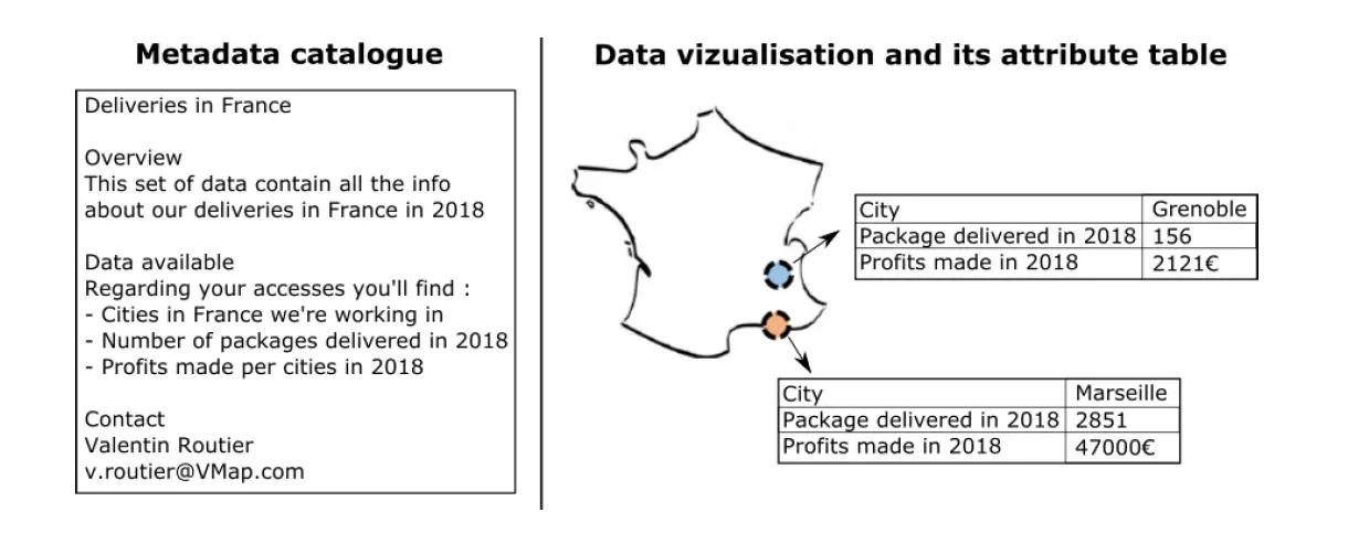
vMAP allow you to add a lot of information related to a specific location which will be stored in the attribute table.
E.g.: for one delivery which is one dot on the map, you can have a lot of information about what was delivered, its price, the name of the deliverer…
And to make sure that you can easily find your data on the platform vMAP is adding for each layer of spatial information, an instruction manual called metadata.
Now you can easily visualize, analyze and manage your private data. But that’s just the top of the iceberg because vMAP allow you to couple your information with Open Data. As said before, Open Data allow you to freely get and use different kind of information (E.g.: road network, cadastral data, land use…)
E.g.: in the previous example, all the solution proposed where made thanks to the use of the road network available on Open Data. Which mean that you don’t need anything more than the vMAP solution to increase the value of your data.
If we stick with the delivery company case, having your own portal client with the vMAP solution allow you optimize the way your work and increase the knowledge you’re having about your company.

With an Excel sheet of your deliveries, vMap will allow you to have this type of visualization where you have the road itinerary for a deliverer: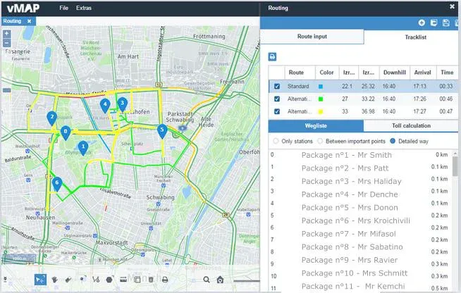
Control your data and what people are doing with it
To make sure that your data is safely used, vMAP is providing an account management system making you in charge of what people can see and do with your data.
You can create for each person or positions, the list of the data they can see or update, the analysis they can do, if they can download data or not…It is making life easier for each position in your company, from the top to the bottom.
E.g.: you are a delivery company and you want to plan an automatic solution increasing your performance. Here’s a quick solution vMAP could help you setting up with its portal client:

In this example, deliverers will only see the previous screenshot from VMap you saw. The local manager will have access to other type of information such as the type of vehicles the company is using (programming the type of vehicles and its height is important to get a better cost calculation of its journeys and the road itinerary too).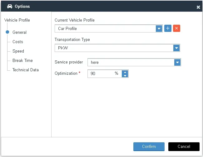
But more important, the VMap solution is going to create you a full database of your company’s information as you can see in the next screenshot. Here, the local manager must create the different folders and with the help of the VMap support (or with tutorials), he and the regional manager will have access to a large panel of information regarding the deliveries, the profits, the staff and more.
In the picture below, most of the files are not geographical information but it doesn’t matter because VMap can also be used as a server for your data. Keep all your data in one safe place!
An immediate solution working 24/7 with low technical requirements
Having your own secured portal client is a solution working 24/7 which doesn’t require any software or a powerful computer. This is making the vMAP solution extremely accessible, giving you a reaction time you can’t find anywhere else.
E.g.: you can update your data through the portal client and have it updated immediately for all the other users.
We’ve been talking about technical solution during this paper which can be frightening for anyone who’s not a GIS technician; But hopefully, all the technical work (automation, coding…) has already been made by the vMAP’s team. The user just need to follow the detailed tutorial available on our website or let the vMAP tech support guide you.