GIS A Tool More and More Useful to the CRM
It’s been a couple of years that GIS or Geographic Information System is being utilized in the CRM or Customer Relationship Management. Usually dedicated to the cartographers or topographers, these tools are nowadays used by anyone seeking clear data visualization.
Main functions of a GIS tool
In every GIS system, there are the maps on one side and the data on the other. The maps are being made by the solution you’ll be using and the data is going to be a mix between yours and the one the solution will be able to get on Open Data.
The main goal of the solution you’ll be using is to put through all these different sources of information in a dynamic and intelligent way.
E.g: a chain store looking to open a new shop will be able to visualize if it has already customers living in this neighborhood (private data) with the medium income of its inhabitants, the density of population and the other stores around (Open Data).
Moreover, GIS isn’t only offering data visualization. Most of the solutions in the market are also allowing you to operate powerful calculation function and analyzes. We’ve got for example the proximity analysis (how many customers are living in this area) or spatial analysis (how long my customers drives to shop in my business)
Regarding the CRM, GIS can help treating the important volume of data available but non utilizable in its actual shape.
E.g.: you have an Excel spreadsheet with 8500 lines with your customers’ info. It’s not easy to get some value out of it unless you’ve got a GIS solution taking care of integrating your data and easing the analysis process.
Setting up a GIS solution in an information system isn’t as complicated as it used to be. Nowadays, we’re seeing solutions like vMAP offering friendly users interface blending in your information system. It’s helping you to get extra value to your data, which isn’t always clear (E.g: the Excel sheet above).
This type of solution isn’t altering your actual information system because you are the one picking up the data you want to upload on a secured server where all the calculation functions, analyzes and data visualization are taking place.
This kind of methodology is helping anyone seeking for data analysis/visualization to reach its goals in the most easily and efficient way.
A cost flexible regarding the complexity of the project
The costs of GIS solutions available in the market are extremely variable. We were used to only find software requiring coding and database management skills but nowadays, light solutions appears with most of the coding and the tools development already made.
These light solutions are friendly users and are listening to your needs so you only have the tools you want (which avoid you paying for tools you won’t need).
Solutions like vMAP are offering a free trial and allow you to contact qualified GIS technician to help you creating your project before even buying the product. This way, you can start with a simple solution with all the tools you need and upgrade it later if needed.
Regarding your information system, few changes would be necessary to set up a long term GIS solution. In some cases, the way the data is collected will have to be slightly modified to make sure that the GIS solution can integrate in real time the data.
E.g.: it is easier for a GIS solution to geolocalize addresses from an Excel spreadsheet if there’s one column for the address, another one for the post code and one for the city. These changes aren’t fundamental because you’ll still need the data; the only constraint is to always collect it the same way.
From cartography to geomarketing
Simple tool allowing data visualization in its primary versions, GIS is nowadays a powerful solution offering many other functions. Primarily used in sectors like environment, urban planning and more recently telecommunications, this type of tools is becoming a key solution for geomarketing.
Mixing private data (customer database) with Open data is allowing you to proceed to interesting data visualization as said before. It’s going to help you see through yours huge Excel spreadsheet.
Many solutions exist to reach these objectives. We’re here going to utilize the vMAP solution, which doesn’t require any GIS skills. Everything here has been done in a couple of minutes thanks to their documentation.
In the example below, we can see how a business owner of 4 shops (stars on the map) can visualize where its customers are living (thanks to the data on their loyalty cards) and especially the ones spending more than 50£ worth of goods per months (calculation made with the vMAP solution).
To do so, the user just needed to upload its Excel spreadsheet containing the information related to the loyalty cards and its store location. Vmap geolocalized them automatically and offered different type of calculation for a better analysis.
To move further on, it would also be possible to create a catchment area with the vMAP solution regarding different criteria (E.g: create an area which represents a 10 minutes drive around my shops). This way, it’s possible to get information about the possibility of opening a new store in the North-West section of the map (after crossing it with data about the medium income, the density, the competitive shops around etc.)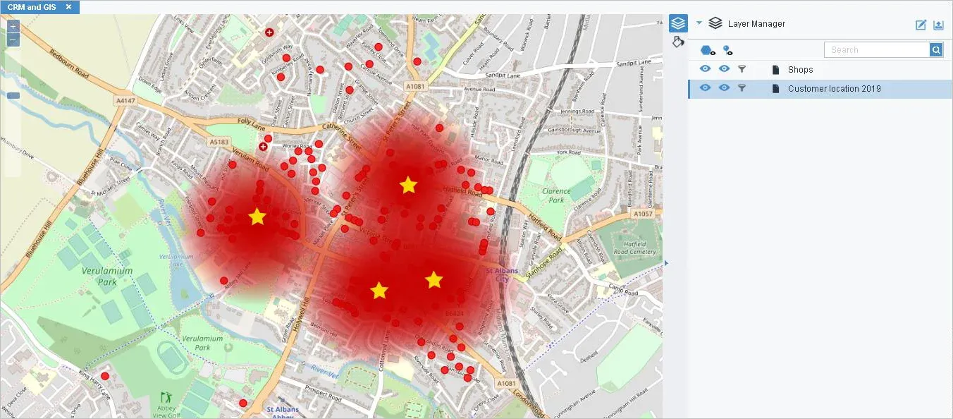
These types of data visualization are permitting you to have a good overview of your activities in the blink of an eye.
And to call centers
Unexpected clients, call centers are more and more using GIS in their work thanks to the mix of data it’s allowing. It’s improving the quality of works of many stakeholders and can be critical.
E.g.: The fireman’s call centers receive a call for an emergency. The person receiving the call can decide which casern is the nearest to go on site. Moreover, if there’s person injured and regarding the nature of the emergency, it’s possible to know in which hospital it’s better to go to.
Mixing GIS and CRM is adding an extra value to your company thanks to the effectiveness and the rapidity in which you can get information. In a call center, it’s allowing you to get closer to your customers and provide a quick and precise answer.
It’s also easing the repartition of the company’s resources and save you time. With solutions like vMAP, you can develop in a couple of weeks a sustainable solution utilizable by your employee who won’t require any software engineering skills, coding, or GIS competences.
E.g.: the example below shows a screenshot made from the vMAP solution where a delivery itinerary has been automatically been made for the deliverer thanks to the call center’s data uploaded the day before. It’s optimizing human resources in a way we’ve never seen before.
Many solutions are available in the market. In this article, we’ve been working with the vMAP solution, offering a free and secure portal so you can work from everywhere you want without any requirement such as installing software, coding, managing database.
The main interest of this solution is that it’s coming on top of your information system. You won’t have to change anything in your company’s infrastructure because of vMAP. Moreover, you’ll have a tech support team available 24/7 if your needs are evolving to help you go through with your project.